Collection in Focus: Digital Maps from the Muller Collection
Digitisation of cultural heritage
27 March 2026

Three heritage items from the Muller Collection
In 1910, the Royal Dutch Geographical Society (Koninklijk Nederlandsch Aardrijkskundig Genootschap, KNAG) purchased the entire stock of maps from the well-known Amsterdam antiquarian bookshop Fred. (Frederik) Muller. The UvA now holds this collection on long-term loan. It mainly consists of loose maps taken from Dutch atlases of the sixteenth, seventeenth and eighteenth centuries.
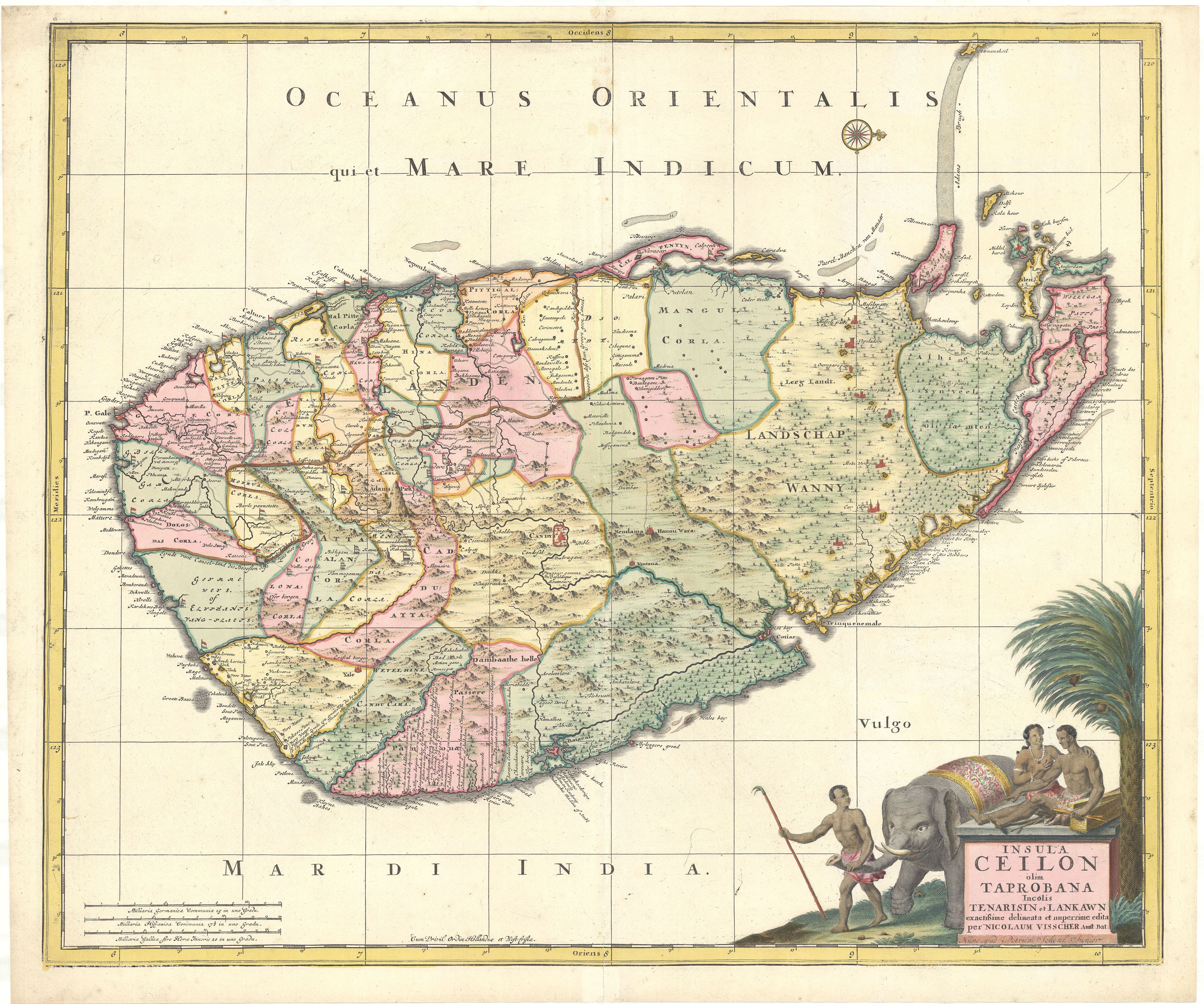
This map of Sri Lanka is a reprint by the Amsterdam map publisher Peter Schenk Jr of an earlier map by Nicolaes II Visscher (1649–1702).
Map of Sri Lanka
From the seventeenth century until 1802 there was a Dutch colonial presence on this island, and the map reflects this in the many forts flying the Dutch flag and in place names in the north such as Amsterdam, Middelburg and Hoorn. The research project Globalise at the Huygens Institute uses AI to read the place names on the digital map so that they can be linked to VOC (Dutch East India Company) archives. For researchers at the Copernicus Institute of Sustainable Development at Utrecht University, this digital map is important for their quantitative research into the ecological footprint of colonial agriculture.
This is one of the oldest maps of Suriname, published by Joachim Ottens at the beginning of the eighteenth century.
Map of Suriname
In this period (early eighteenth century), Dutch colonial rule was focused on plantations producing sugar and coffee, where the heavy labour was carried out by enslaved people. This map only shows the houses and names of plantation owners in Suriname, and not the presence of deported Africans. The prominent depiction of rivers and streams is meant to show readers in the Netherlands that the plantations are easily accessible by water. This digital map and other digital sources on the history of Suriname are brought together by the Suriname Time Machine.
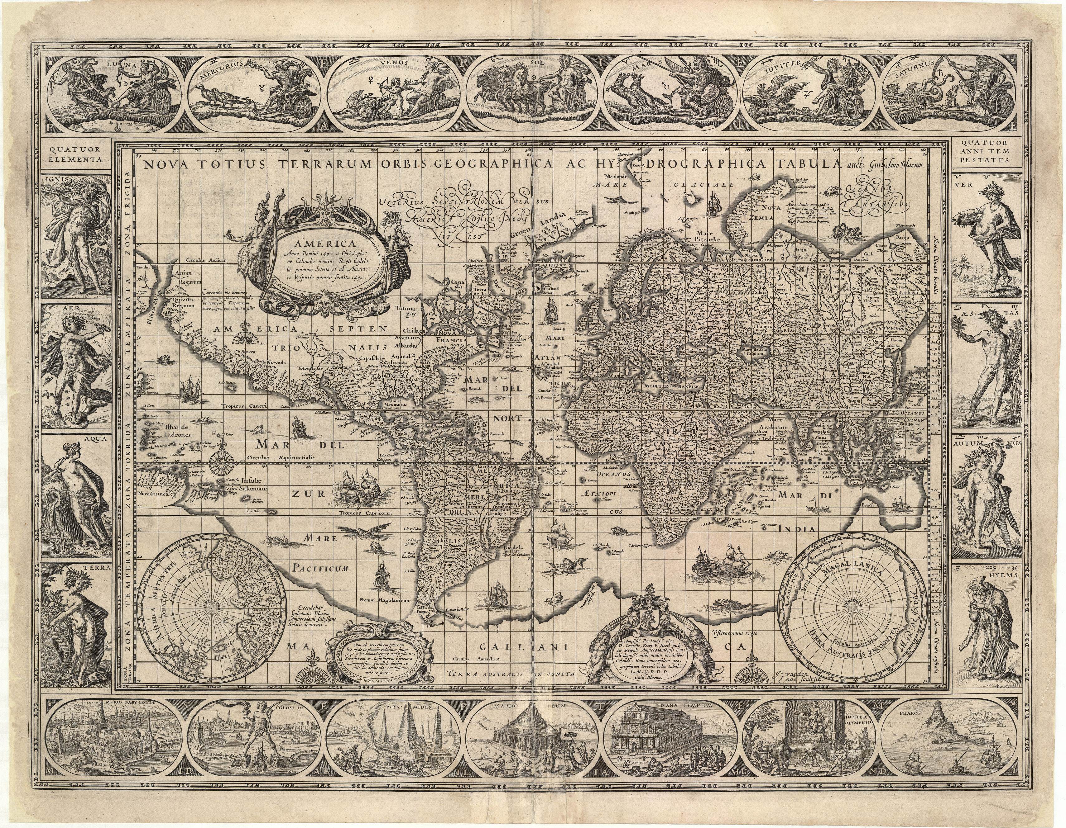
The famous Amsterdam mapmaker Willem Jansz Blaeu printed this world map from 1630 onwards for various editions of his atlas. The map clearly reflects the seventeenth‑century worldview: Europe is depicted as the centre of the world.
World map
Because of the Mercator projection, Africa and South America appear smaller than they are in reality. Much of the rest of the world is unknown – to Europeans, that is. Around the map is a decorative border showing the four elements and the four seasons. At the bottom are the Seven Wonders of the World, and at the top the seven planets. This reflects a geocentric view of the universe, with the Earth at the centre, which aligns well with ideas from biblical stories.
Project ‘Verbonden kaarten’ (Connected Maps)
In recent years, thousands of maps from the heritage collections of the University of Amsterdam have been digitised. In the past few months a catch‑up effort has been made to make these maps accessible: around 1,000 maps are now available online, and another 2,000 will be added before the summer.
This has been made possible in part by a grant of €75,000 for the project “Verbonden kaarten” (“Connected Maps”), awarded to the Allard Pierson and the UvA/AUAS Library in collaboration with the Amsterdam Time Machine and TU Delft. The grant comes from Stichting PICA as part of the programme “Connected Digital Heritage”, which aims to make digital collections easier to find and share.
Thanks to this funding, digitised maps from the Allard Pierson collection can be made more accessible. Through the online application Allmaps, the maps are linked to OpenStreetMap by means of georeferencing. This makes the maps geographically searchable and accessible online. Thanks to the support of Stichting PICA, the digitised maps from the Muller Collection are now being put online more quickly and processed via Allmaps.